Clouds are closely associated with weather. Clouds are of different types and there classification is based on the height of the cloud’s base above the earth surface. Clouds can be of any shape and size and are normally water droplets or frozen ice crystals that float above the earth atmosphere. It is really a great fun to watch clouds floating from one direction to another, especially when you are in plane. Due to their marvelous appearance many photographers has captured amazing and astounding snaps.
Clouds are Water
Almost all of you are aware of this fact that clouds are actually water. We can found water in three forms that is, in solid form, liquid form or in gas form. The gas form of water is known as water vapor. When these water vapors turn back into liquid water droplets through the process of condensation, clouds are formed. Condensation process occur in one of two ways: when the air cools down enough, or when enough water vapors are added to the air. The illustration of first process is really simple. On any summer day, you have often seen drops of water gather on the outside of the glass of ice. This is because the cold glass cools the air down which is nearby it, causing the water vapors to take the liquid form. However, the droplets formed in a cloud are extremely small that it can take about one million drops to form a raindrop. This is how most of the clouds are formed, i.e. when air rises above, it cools down high in the sky. The droplets are light enough to float in the air.
Types of Clouds
Cirrus
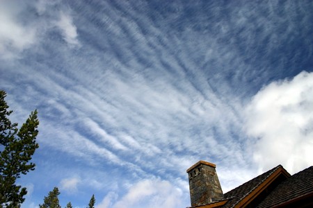
Cirrus clouds are classified into four sub-types: Fibratus, Spissatus, Uncinus and Spread. Cirrus clouds are formed at high altitudes (5000-13000m). Out of these four sub-types, Cirrus Fibratus and Cirrus Spissatus are ice clouds. Cirrus clouds normally predict a fair weather. However, it the wind is steady from NE or E to S, the precipitation will possibly within 20-30 hours of that time. Cirrus Uncinus and Cirrus Spread are the sub-types that are formed higher than Fibratus and Spissatus.
Cirrocumulus
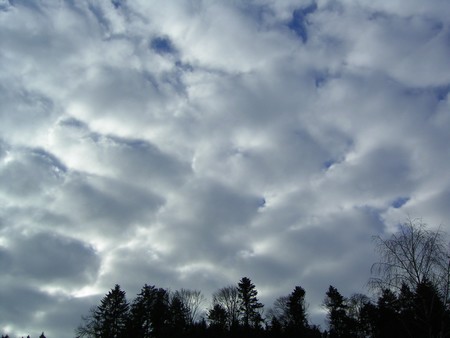
Cirrocumulus clouds also belong to the high cloud group form at high altitude (6000-13000m). These are large clouds, appear in long rows. Each cloud is of the size of the finger held at arms length. Mostly, cirrocumulus clouds are white but occasionally they are gray as well.
When these clouds cover a lot of sky, it is called ‘mackerel sky’, because it appears to be like scales of a fish. Cirrocumulus clouds usually appear in the winter and predict fair and cold weather.
Cirrostratus
Cirrostratus clouds are thin, uniform clouds and belong to the high cloud group (5000-13000m). Cirrostratus clouds are capable of forming halos around the sun or the moon. The halo is formed because the ice crystals present in the clouds breaks the light from the sun or the moon. The halo is not larger than the width of your hand, when you hold it at your arm’s length.
Cirrostratus clouds usually appear 12-24 hours before the rain or snow storm, especially when they appear along with the middle cloud group.
Altocumulus
Altocumulus clouds belong to the middle cloud group formed at the altitude from 2000-7000m. These clouds are grayish white in appearance and one part is relatively darker than the other. Altocumulus clouds are about 1 km thick and appear in groups.
When you hold your hand at arm’s length, they appear to be as wide as your thumb. The appearance of the thick altocumulus clouds early in the morning, predict rain by afternoon.
Altostratus
Altostratus clouds also belong to the middle cloud group which is formed at the height of 2000-7000m. These clouds have a grayish or bluish-gray appearance. You can see the sun or moon through the clouds, giving watery or fuzzy appearance.
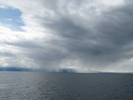
Altostratus clouds normally appear before the storm with continuous rain or snow. Often altostratus clouds cause the rain to fall. In such case, these clouds are classified as nimbostratus clouds.
Stratus
Stratus clouds belong to the low cloud group and formed at surface to 2000m. Stratus clouds are uniform gray in color, usually spread all over the sky and appear to you like a fog. Stratus clouds can sometime responsible for light mist or drizzle.
Stratocumulus
Stratocumulus clouds come under the low cloud group (surface-2000m). These clouds appear to be lumpy, low and gray. Sometimes you will find them lineup in rows, while at other times they spread out. They usually look like cells under a microscope.
If you see stratocumulus clouds in the sky, you can expect to have a light drizzle. You can distinguish between stratocumulus clouds and altocumulus clouds by simply point your hand toward the cloud. If the clouds appear to be the size of your fist then they are stratocumulus clouds.
Nimbostratus
These are also come under the low cloud group (surface-2000m). These clouds have a ragged base and dark gray in color. Nimbostratus clouds normally cover the whole sky and can be responsible for continuous rain or snow.
Cumulus
Cumulus clouds are the clouds belong to the Vertical Growth group. These clouds have a flat base with sharp outlines. These clouds are puffy white or light gray in color and look as if floating cotton balls. Cumulus clouds are formed at the height of 1000m, having a width of 1km.
Cumulus clouds are of two types: cumulus humilis clouds predict good and fair weather, while cumulus congestus clouds are known for bad weather. They have cauliflower like head and predict mild or heavy rain showers.
Cumulonimbus
These clouds also belong to the Vertical Growth group. Cumulonimbus clouds are commonly known as thunderstorm clouds and are therefore associated with heavy rain showers. These clouds are formed at the height of 10 km where winds flatten the top of the clouds and given them the shape like an anvil.
Lenticular
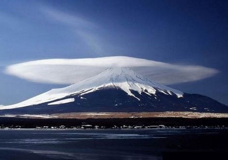
The clouds formed on the downwind side of the mountains are known as lenticular clouds. You have often seen moving clouds slowly form one direction to another, but this type of clouds appear to stand still in one place. These clouds are formed when the air moves up and goes past the mountain top. Lenticular clouds are lens-shaped clouds and seem like a flying saucer.
Kelvin-Helmholtz
If you have ever noticed the breaking waves of the ocean, you will easily recognized Kelvin-Helmholtz clouds as they bear the same shape. The difference in wind speed or direction between two wind currents in the atmosphere is responsible for the formation of these clouds.
Contrails
Condensation trails are also called as contrail, which are white streaks formed by a high flying jet plane. Contrails are types of clouds formed when water vapor condenses and freezes around the aircraft exhaust. Water vapors come from both the air and exhaust of the aircraft.
Some contrails stay in the air for long time while others evaporate rapidly. When the air has excess amount of water then these contrails stay for long.


